Data-Visualization and Mapping Tools Help New Jersey Communities Plan for Climate Change
The expanded suite of apps will assist decision-makers to predict and prepare for future events and conditions
New Jersey residents and planners alike have a new set of decision-support tools to help prepare their communities for climate change, thanks to a suite of data-visualization and mapping tools developed at Rutgers University’s New Jersey Climate Change Resource Center.
The tools are part of a suite of data-visualization and interactive mapping applications known as NJADAPT.
“Hurricane Sandy’s impacts along the New Jersey coast made clear the importance of understanding the risk of coastal flooding,” said Lucas Marxen, associate director of the Rutgers NJAES Office of Research Analytics and a member of the NJADAPT team. “In the 10 years since Sandy, the NJADAPT Team has worked to provide data and decision support tools to help communities prepare and become more resilient.”
Additions to NJADAPT include:
- A Climate Dashboard of projected climate trends and statistics by season
- Improved Climate Snapshots about the people, places and assets at risk by municipality, county and statewide
- NJ HazAdapt, developed with the New Jersey Office of Emergency Management, to aid in county and local hazard mitigation plans
Enhancements include a primer on coastal flooding and an overview of a climate planning tool to analyze coastal flooding vulnerability.
"A main function of the NJ Climate Change Resource Center is to provide useable science to help New Jersey communities and decision makers plan for the cascading impacts of warmer temperatures, more intense precipitation, and sea level rise,” said Marjorie Kaplan, co-director of the center.
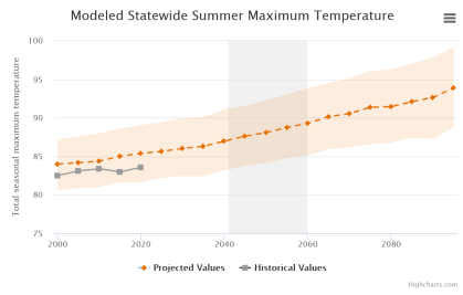
The new Climate Dashboard visualizes climate-change trends and statistics for New Jersey. It compares today’s conditions with future projections and can be displayed as maps or interactive charts. The projected changes are summarized in seasonal intervals for six climate measurements in moderate and high (continued growth of emissions by 2100) emissions scenarios.
The researchers said adapting to climate change requires understanding potential hazards and exposure. Climate Snapshots provide access to information about the people, places and assets at risk from climate impacts in New Jersey’s municipalities, counties and the state.
Climate Snapshots include reports on built infrastructure, critical assets, natural and working lands, public health, vulnerable populations and forestry.
HazAdapt, developed with the state Office of Emergency Management, provides municipal and county hazard planners with access to data and resources to assist with developing hazard mitigation plans. State and local users can assess flooding impacts on crucial Federal Emergency Management Agency lifeline sectors, socially vulnerable populations and individual land parcels. The tool includes heat hazard data to understand the impacts of heat waves and the urban heat island effect.
Other tools include NJFloodMapper and NJForestAdapt, both of which have been improved and updated with new data.
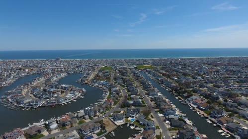
Focused on flood-related hazards in New Jersey’s 239 coastal municipalities, NJFloodMapper helps quantify and visualize the impacts that rising seas, coastal flooding and other hazards will have on coastal communities, critical facilities, socially vulnerable populations, natural systems and other assets.
NJForestAdapt informs forest stewardship and community forestry-management plans, efforts to protect watersheds, resiliency planning and adaptive management in New Jersey in the face of climate change.
“We have been working together on issues related to preparedness in the face of sea-level rise in New Jersey since before Sandy, but that seminal event pushed efforts into overdrive,” said Kaplan. “Expanding NJADAPT gives communities more tools to use to prepare for the climate-related impacts we're already experiencing and will continue to see in the future.”


